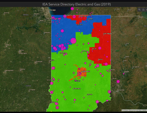

Indiana Broadband Map
The Indiana Broadband Portal was designed to provide tools for searching and visualizing broadband availability anywhere in the State of Indiana. 39°N designed and created an application using ArcGIS Web App Builder and ArcGIS Online. Users are able to click on a map or enter an address to receive a listing of broadband service providers for that location. Administrators are also able to edit broadband territories in the system through a secure login.
Description of Work Performed:
- Design and develop the web application for the Indiana Broadband Map using ESRI and Web Standards that met the Indiana Office of Technology (IOT) guidelines.
- Design and develop the mobile application for Indiana Broadband Map using ESRI and Mobile Standards that meets the IOT guidelines.
- Aggregate data provided from various providers that met the standards created by the National Telecommunications and Information Agency (NTIA) for the National Broadband Map.
Significant Achievements, Challenges or Obstacles:
Displaying over 1,970,000 census block level data in a web viewer.
The data that was received from the various service providers were not always in a standard format. Advanced data analysis techniques and scripts were developed to make the aggregation process more streamlined and standardized.
Displaying over 1,965,000 records of data at the census block level posed various challenges in terms of display speed and rendering. This was overcome using the latest vector tiling method of caching using ArcGIS Pro and publishing vector tile package as a tile service on ArcGIS Online. Using this vector tiles we were able to achieve fast rendering and filtering of data in a browser.